
Central Coast Active
Central Coast Active Flip-Book
Access Publishing
Along a panoramic ridgeline that extends from the city of San Luis Obispo to the coast of Morro Bay, rises a rare, nearly straight alignment of rugged hills and craggy peaks collectively known as the Nine Sisters.
Formed over 25 million years ago, the nine prominent peaks, also known as the Morros, are a set of eroded lava plugs from ancient volcanoes. Together they cover a 40 square-mile area from the famed Morro Rock in Morro Bay to Islay Hill located on the southeast side of San Luis Obispo.
Part of the Santa Lucia Mountain Range, these sibling guardians of the valleys below not only provide beautiful scenery, recreation and a sense of place for local residents, but are also home to a variety of endangered wildlife and vegetation species. Their unique geological features also make them a valuable educational tool for teachers and students of area schools and universities.
Through the cooperation of landowners and the efforts of individuals, public agencies and private organizations, the ancient volcanic mountains have become more accessible for recreational activities in recent years.
Visitors to the Morros Chain can access trails on the following peaks:
Black Hill, Morro Bay State Park
Cerro Cabrillo, Morro Bay State Park
Cerro Romauldo – with permission from Camp San Luis
Bishop Peak, off Patricia Drive
Cerro San Luis Mountain, Maino Open Space Area
Islay Hill, off Tank Farm Road
Bishop Peak
With an elevation of 1,559 feet, Bishop Peak stands as the highest of all the sisters in the Morros Chain, towering over the city of San Luis Obispo and the California Polytechnic State University campus below. It was given its name in the late 18th century by the padres at Mission San Luis Obispo who thought the summit’s three sharp points resembled a bishop’s miter cap.
Acquiring the land for what has become the 360-acre, Bishop Peak Natural Reserve, was a cooperative effort between landowners, donations from the Sierra Club and grants received by the City of San Luis Obispo. Additional support from public funding, the Chamber of Commerce, San Luis Obispo County, the Land Conservancy and state officials ultimately secured and retained the land in early 1998 for recreational activities and further study.
Through the efforts of the Sierra Club, California Conservation Corps, California Department of Forestry and volunteers, the trail to Bishop Peak was completed on June 1, 1999. It offers unparalleled views of the Morros Range and encompasses a variety of habitats from grasslands to dense woodlands and chaparral.
Hike Overview
Hiking to the summit of Bishop Peak is practically a rite of passage among local residents and Cal Poly students ranking it among one of the most popular trails in the county. Weekends and holidays draw a crowd, which can make parking on Patricia Drive part of the hike.
With the peak in view, enter through the trailhead and continue on the wide dirt path for about 0.2 miles to the junction of the Bishop Peak trail and the Felsman Loop trail. At this point, you can either continue on to Bishop Peak by taking the trail left and up the hill through several shady switchbacks, or you can veer right up a paved road to take a longer hike around the Felsman Loop trail. This 2.7-mile loop meanders through groves of coast live oaks and around the base of Bishop Peak. It’s an easy to moderate way to enjoy the views, flora and fauna of the reserve. Ultimately, the Felsman Loop and Bishop Peak trails reconnect after roughly 2 miles.
After the series of switchbacks through oaken woodland, our original route up to Bishop Peak opens up to a seasonal cattle pond. Veer right, past the pond, and continue uphill to a cattle gate bearing arrows that point to Bishop Peak to the left or to the Felsman Loop trail to the right.
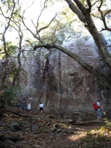
The Bishop Peak trail continues its moderate ascent through a shady forest of oaks and jagged boulders that seem to grow larger with the incline. Suddenly, the path opens and reveals the Crack Wall, a popular rock climbing area.
Exiting the forest, the single-track trail begins switch backing up the south side of Bishop Peak. This is where the hike begins to feel strenuous as you navigate over 1.05 miles of elevation gain along the rocky, sun-exposed mountainside. Along the way, generous views of sister Morros, Laguna Lake and the Chorro Valley below offer a good excuse to rest and take it all in.
As you reach the peak, two benches mark the end of the trail between the west and east summits. Here you can either rest before heading back down or carefully scramble up and over large boulders to the east and west to gain the ultimate elevation and enjoy outstanding views.
Cynthia Shaheen - freelance writer and outdoor enthusiast.